
Tiguentourine Fm
Type Locality and Naming
Defined in the Edjeleh area of eastern Algeria by de Lapparent & Lelubre (1948)
References: Lapparent & Lelubre, 1948; Freulon, 1964; Fabre, 1970, Goudarzi, 1970; Bertrand-Sarfati & Fabre, 1972; Lababidi et al., 1985; Attar et al., 1981; Mergl & Massa, 2000; Fabre, 2005; Tawadros, 2011; Shalbak, 2015; Hallet, 2002, 2016.
Synonym: Tiguentounine Fm (misspelling) . Equivalent(s): Mergl & Massa (2000) state that the lower part of the Tiguentourine Fm is the equivalent to the “*Madama sandstones”. They are exposed near and around Madama, a military fort in the central part of the basin.
Lithology and Thickness
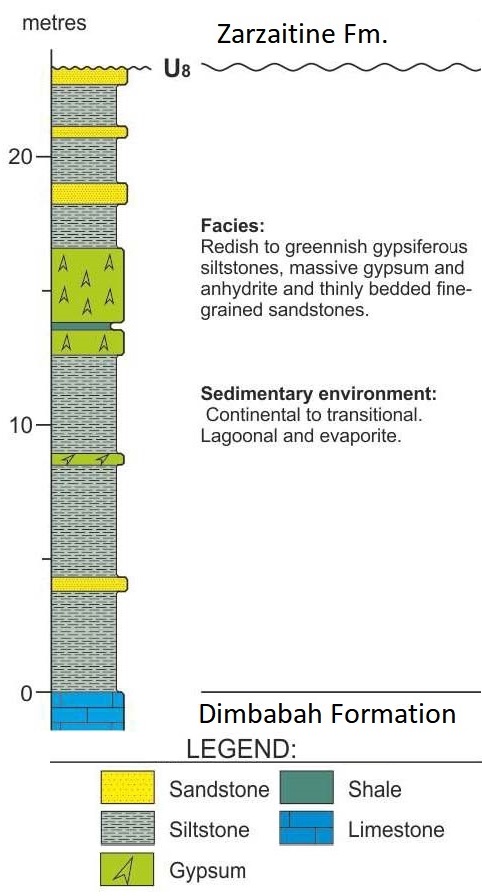
The lower part is made up of red and green shales with primary dolomites. There is a massive gypsum bed (2 to 4 m thick) and reddish cross-bedded sandstones in the upper part. (Fig. 1). Thickness: 80 m at the Type Locality in Algeria (Hallet, 2002). However, Attar et al. (1981) describe a 240 m section; 100 m in the Djado Basin; 200 m in Libya (Mergl & Massa (2000)).
[Figure 1. Stratigraphic column of the Tiguentourine Fm at the Locality Type in Algeria (Source: Modified from Shalbak, 2015).]
Relationships and Distribution
Lower contact
Disconformably overlies the Dimbabah Fm
Upper contact
Conformably overlain by the Zarzaitine Fm
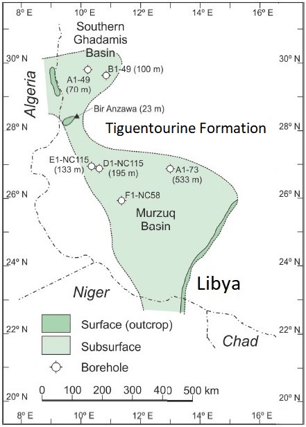
Regional extent
[Figure 2. Outcrop and subsurface extents of the Tiguentourine Fm in Libya and Niger (Source: Shalbak, 2015).]
GeoJSON
Fossils
The lower half contains thin layers of stromatolitic limestones rich in Euestheria (E. simoni and E. tenella) associated with palaeoniscid and selachian fish fragments. Attar et al. (1981) describe Acanthodian, Elasmobranchs and Actinopterygians fragments preserved in ferruginous nodules.
Age
Depositional setting
Fluviatile or lagoonal environment (lower part); fluvial environment with evidence of aeolian influence (upper part).
Additional Information